Our friends and biking buddies Brock and Leola have been showing us around the Traverse City area of Michigan. Tuesday we explored the inland area south of the city. Wednesday we rode north along the inside (eastern) edge of the Leelanau Peninsula, and yesterday we poked along the spit of land in the middle of Grand Traverse Bay.
Today's ride took us along the western edge of the peninsula where we visited the Sleeping Bear Dunes National Lakeshore. The Lakeshore runs from just south of Leland to halfway between Platte River Point and Betsie Point.

We began our exploration by riding through the Port Oneida Rural Historic District. Once a dock, sawmill and farming community, the sawmill closed when the trees were all cut, and poor soil conditions forced most families to move. Today the National Park District is gradually restoring the abandoned buildings.

We stopped at the Sleeping Bear Point US Life-Saving Service Station Maritime Museum. From 1871 to 1915 courageous surfmen and keepers rescued over 178,000 people from shipwrecks in the Manitou Straits. In 1915 the USLSS merged with the US Revenue Cutter Service, forming the US Coast Guard.
Rescue boats were launched into the lake via these rails.

We were in time to join a presentation of how the rescue lines were shot to the wrecked ship where the crew secured them to the ship. Crewmen were then ferried from the ship to the shore. Boats were sometimes launched, but the line rigging was the most common method of rescue.

Glen Haven was a stop for ships to take on fuel wood, and provide food, lodging, and services for travelers along Lake Michigan. Visionary businessman David Henry Day bought land in the area and developed it into a lumbering, agricultural, and tourism center. The Great Depression ended the town, but the Park District maintains the fruit cannery (now a boat museum), general store (gift shop), and working blacksmith shop.

We saw the big sand dunes area via the Pierce Stocking Scenic Drive, a beautiful rolling paved road linking 10 overlooks offering views of various points along the dunes. (This is a fee area, but we flashed our National Parks Passes and were waved right in.)

We stopped at two. This one shows Lake Michigan on the horizon. To the right

we saw part of Mr. Day's farm holdings in the left and Glen Lake on the right.

Stop 9 had a viewing platform of this steep 145' dune. Lots of people ventured down the dune anywhere from a few feet to the shoreline at the bottom. They all had to climb back up in the loose, shifting sand.

Our tour ended at the town of Empire where we found the park headquarters at the Philip A. Hart Visitor Center. (This was to have been our starting point, but we missed a turn and ended up going south instead of north.)
The Center held displays of plants, animals, pictures, maps and other information about the park. We stamped our National Parks Passports here and at Glen Harbor.

I was most impressed with this Lakeshore mural. It is impressive when first viewed, but simply amazing when you realize it is four quilt panels!
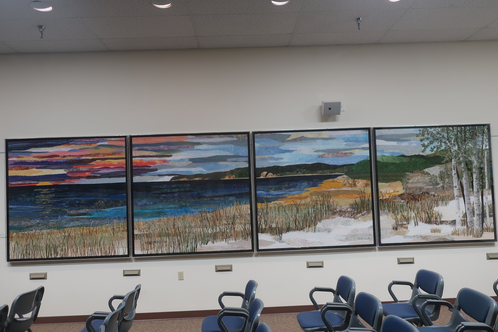
Details of the fabrics and stitching used on the water, grass (each stem is a seprarate piece of fabric),

and small bushes (each leaf is a tiny snippet of fabric).

Leaving the Visitor Center we wound through Empire until we found a place to try locally made hand dipped ice cream.

It was tiny, eclectic, and welcoming. After being disappointed on the UP (see Hunting And Fishing blog), I finally found some plain chocolate ice cream. It was really good.

Our tour done, our ice cream eaten, there was nothing left to do but head home.

No more rides planned.
Louise and Duane
No comments:
Post a Comment