 This was our first view of the lake, which kept its sinuey river shape. That 'house' is called Lone Rock.
We followed the lake for a while until we came to

View of the dam.

West of the dam

East of the dam

Bridge and moorings on the Colorado River

Sculpture outside the visitors center. This area is known for its dinosaur connections.

This particular dinosaur looked pretty nasty. I'm glad I wasn't around to see it.

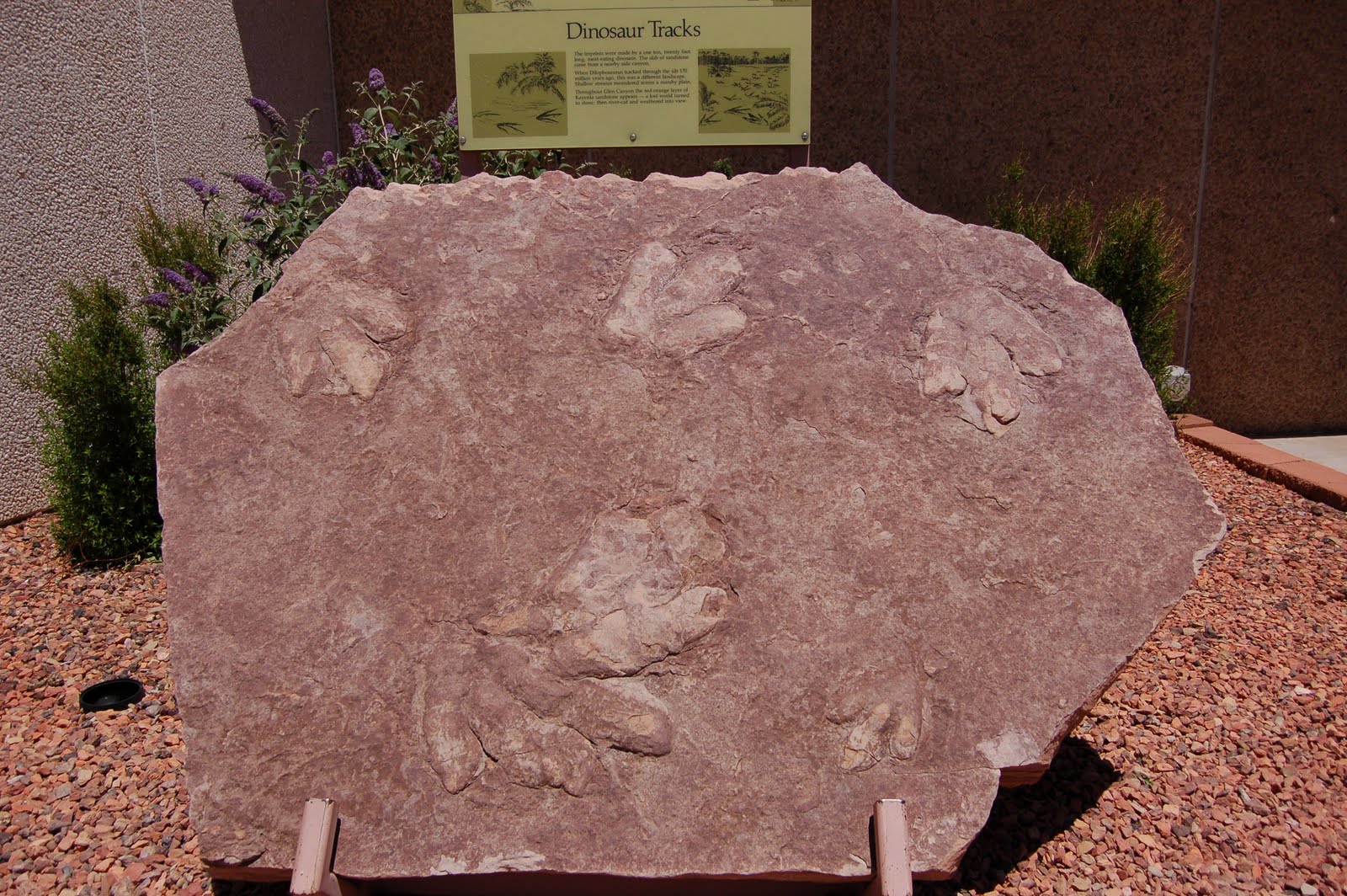
The visitors center is very small but nice. Its main interests are the gift shop and the unusual dinosaur discovered here. As with the Hoover Dam, no weapons (uncluding utility tools) were allowed here. There was no metal detector, but if caught with them you wouldn't see them again. Notice the size of those claws!

After lunch in the parking lot we continued rolling through the desert.
 Now we were out of the red rock and into the gray
 and tan.
I love these formations. They look like pudding.
 Up the hill
 and through the crack
 and into the Navaho Reservation. This is a typical homestead.
 There were several of these roadside stands selling jewelry and various crafts.
 Back in the land of red rocks on SR160.

 Notice the sign that says Hopi Lands.
 From here we turned south on cr264. I believe this is Moenkopi. No town or villages on the reservations (that we saw) were very large.
 Tilled fields in the protection of cliffs to help prevent wind erosion and to channel water.
 In my mind I always associated the Navaho and Hopi with sheep. This is the only herd we saw. Mostly we saw cattle and horses.
 Within the Navaho Reservation is the Hopi Reservation. As we drove the Navaho area, we noticed the beautiful red cliffs. Here in the Hopi Reservation the area was tan.
 The Hopi divide their area into Third Mesa, Second Mesa, First Mesa and Keams Canyon, with different clans living in each area and making different crafts different ways. This is a village on Third Mesa. We drove by here and stopped at Second Mesa at a free boondocking spot. We visited the little museum and gift shop. In the museum were signs warning against taking pictures or even notes, so we have no pictures. One display was of newspaper clippings about the dispute between the Navaho and Hopi over land and how the Hopi were eventually granted land within the Navaho Reservation. I asked the lady at the desk if the disputes were ever solved. She said that the Tuuvi City area (the area in the pix of the Travel Center) was still in Navaho hands and still being disputed.

 Up the hill
  and through the crack
 and into the Navaho Reservation. This is a typical homestead.
 There were several of these roadside stands selling jewelry and various crafts.
 Back in the land of red rocks on SR160.
We stopped here for a break. From here Tuba City is north, Moenkopi south. Tuba City is a mispronunciation of Tuuvi, the Hopi chief who had a vision that the white brothers would return to be reunited with the Hopi. He welcomed and aided the Mormon settlers.
 Notice the sign that says Hopi Lands.
 From here we turned south on cr264. I believe this is Moenkopi. No town or villages on the reservations (that we saw) were very large.
 Tilled fields in the protection of cliffs to help prevent wind erosion and to channel water.
 In my mind I always associated the Navaho and Hopi with sheep. This is the only herd we saw. Mostly we saw cattle and horses.
 Within the Navaho Reservation is the Hopi Reservation. As we drove the Navaho area, we noticed the beautiful red cliffs. Here in the Hopi Reservation the area was tan.
 The Hopi divide their area into Third Mesa, Second Mesa, First Mesa and Keams Canyon, with different clans living in each area and making different crafts different ways. This is a village on Third Mesa. We drove by here and stopped at Second Mesa at a free boondocking spot. We visited the little museum and gift shop. In the museum were signs warning against taking pictures or even notes, so we have no pictures. One display was of newspaper clippings about the dispute between the Navaho and Hopi over land and how the Hopi were eventually granted land within the Navaho Reservation. I asked the lady at the desk if the disputes were ever solved. She said that the Tuuvi City area (the area in the pix of the Travel Center) was still in Navaho hands and still being disputed.
 We got set up and had supper, then walked next door to the nice little restaurant for ice cream before settling in for the night.

Nighty night,
Louise and Duane
1 comment:
What a beautiful visitor's center. You mean you didn't buy any stones at those roadside shops?
I feel like I was in the truck with you two driving down the highway. Great job!
Post a Comment