Sunday, June 19, 2011

TRUTH OR CONSEQUENES and ELEPHANT BUTTE

Leaving Sky City campground on Friday morning, we continued east on I40 thruogh the Laguna Indian Reservation. We passed the usual continually changing high desert terraine until we got to Albuquerque and turned south on I 25. Then we began seeing this--a line of green along the east side of the road, and


hilly desert on the west. We had entered the Rio Grand Valley of New Mexico.


We decided that this is the ugliest rest area we had encountered in our travels. It turned out to be the best. The large buildings in the middle(there's one behind it on the upper deck also) are restrooms--welcomingly cool after the desert heat. The other "rooms" are picnic areas. The ones on the upper deck offer desert views as well as cooling breezes. Not hungry at the time of our visit, we declined the siren call and continued our journey.


Arriving in Truth or Consequences--T'r C--as the locals call it, we cut off on 187 for two miles further south to Williamsburg and the Desert Haven no-kill animal rescue. The spots here are usually filled by work campers, but we got an empty spot. We got full hookup 50 amp for $14 a night. All proceeds fund the animal rescue. After we set up we cruised through TRC looking the town over and arriving at the Wal-Mart at the north end for a few groceries.


Saturday we went to the Geronimo Springs Visitors Center for information and then next door (to the left) to the Geronimo Springs Museum. This place is a wonderful collection of 14 rooms of local history and artifacts. Duane looked over the blacksmithing tools and the very small collection of wood carving art. I admired the handmade quilts, the clothing, and the paintings depicting area historical events.

To the left of the museum is the original hot spring, which is located under this park. The water is pumped up to the top of the two fountain structures on either side of the walkway,


then down the troughs on either side of the park before going back to the spring under the little footbridge where I am standing above.


The onfoboard below offers a little history about the place.


At the museum we asked about places for a good lunch. Four were offered. One Italian place, one Mexican place, the Happy Belly Deli, and BBQ on Broadway. Denied our ribs in Holbrook, guess where we went. We each got a brisket sandwich--Duanes was sliced, mine was chunked. Both were good. Satisfied and full, we walked the other way around the block checking out the stores. For a recession, TRC doesn't have many closed businesses! The town seems to be holding its own. For tourists it offers the Geronimo Museum and the Veterans Memorial Park & Hamilton Military Museum. It lies amid the Geronimo Trail National Scenic Byway from which you can see dramatic scenery and visit several historic mining towns, and is home to 11 different hot springs. These mineral springs run at 110 df and don't smell like sulfer. All are privately owned by lodges and motels, but one offers solace for visitors not staying at the resort. Nearby (10 miles) is Elephant Butte Lake State Park. We got a 15 minute pass to cruise the park. It was a busy weekend. The campgrounds had just a few spots left and the beach was packed.


People were on boats and on the beach, but not many ventured in. The water temperature was 67df!


These pix were taken from atop the dam. Note the high water mark on Elephant Butte Island.


The Rio Grande supplying electricity.


Time to go home. This is our little campground. From the road are: work camper, work camper, us, the mobile home of the manager. The rescue animals are housed behind the manager's house. On this side between the manager's house and the road runs a little animal cemetery for the unfortunate animals.


Tomorrow, more exploring with


Louise and Duane

Thursday, June 16, 2011

El Malpais

It's all Louis L'Amour's fault. I read one of his books set in this area and I just had to come see what he was talking about! The name (Mal pie ees) means the badlands. It is a land of sandstone and lava flows. The park is a funny H shape accessed mainly by two paved roads--117 running n/s on the east side of the park and 53 on the west side of the El Malpais National Conservation Area and curving to border the National Monument on the north and run parallel with part of the Continental Divide national Scenic Trail. From this road a jeep road connects to the west side of the monument giving access to the features there.


We entered the park on 117 and stopped at the ranger station. We learned that the area is a joint effort of the National Parks System and the BLM along with some private owners. It is bordered on the north by the Cibola National Forest and on the other sides by the El Malpais National Conservation Area. Our first stop was the Sandstone Bluffs Overlook Area. The large flat area to the left and center are lava flows dotted by vegetation.


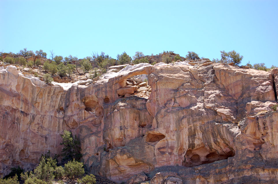
Driving down this road the sandstone cliffs are on the left (east) this is a little natural arch.


Farther down the road was our second stop--La ventana (the window) Natural Arch. The Sandtone Cliff overlook was reached by driving a mile down a washboard gravel road. The arch was an easy walk on a short trail. The arch is fenced off, but we had a good view.


To the left of the arch was a flat-faced rock. Duane swears the left hand blob is a charging buffalo. It took me a while, but I can see it.


On the other side (right) of the road were the ends of the lava flows. The lava flowed for up to 20 or so miles from the string of volcanoes on the north and west of the park. There were several different flows piled on each other over millions of years.


Above and below, east and west sides of the road.


This is part of The Narrows, where the flows ended very close to the cliffs. Just beyond this section of road the area opens up to grasslands, and the home of the prairie dogs. Some of the holes were right at the edge of the road!


Just past the grasslands we reached our final objective--the Lava Falls Area. This is a one mile walk over the flows. This is what I had come to see--what the main character in the L.L'A. story had to contend with. We grabbed our floppy hats, water and hiking guide and took off. We were amazed at how many different features we saw as we hiked along. The trail was marked by large cairnes, and 9 different points of interest. We learned the names of the different kinds of flow features and how they were formed.


This flow is only 3000 years old and flowed over an older layer. It was like walking on clinkers.


There was life everywhere: lichens, pinyon pines, wildflowers, cacti. Everything was stunted and low to the ground, but it was there. There were also lots of flies!


We gave this the technical name of "pudding".


This is what gave the hike its name--a lava fall. It was formed when one lava flow slowly dripped over the edge of a previous flow. The small recesses behind the fall is a perfect habitat for moss and algae.


Hiking along.


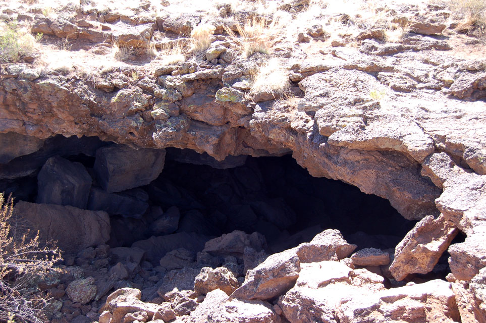
By the time we got back to the truck, we were hot and hungry. All along this road are little picnic areas with pit johns. We opted to backtrack to the Narrows Picnic Area where the picnic tables are all covered. We cooled off and enjoyed our lunch before we decided to try the west side of the park. We drove part way west on old RT 66, then jumped on the highway to 53. We drove 20 south of Grants past cliffs on the right and grasslands on the left to reach the El Calderon Area. We wanted to see a lava tube, a lava lava trench, a cinder cone and a couple of "sinks". We didn't want to hike the three mile loop trail to see all of these features. We thought we could take the unimproved road around the area. Unfortunately the road was a jeep trail which means it was probably too narrow and rough for our big dually. We contented ourselves with viewing both ends of the lava tube, which was right there at the parking lot. Ordinarily we would have been able to crawl through, but all caves in the area are closed because they house bats, and because White-nose-syndrome is not in this area yet. This is actually a fungus that grows on the noses and wings of bats. It is not harmful to humans, but no one knows how it gets into the hibenation caves, so with the idea that humans may be intorducing it, all bat caves are closed!


It doesn't look like it but this is open through to both ends. It was formed by cooling lava collapsing and creating a tube. This one is about 10-15 feet long.


This completed our tour of El Malpais. I was satisfied that I could reread that story and get a really good picture of the area. We went back to Grants, hit the Wal-mart for a few groceries and got home about 5pm. Since we had food in the house again, we decided to walk next door to the casino for supper. LOL. It turns out that they have a featured buffet every night. Tonight was flat-iron steak night, cooked three different ways. For the bargain price of $12.99 we got steak, hot vegetables, baked or mashed taters, salad bar and desert bar. Yum yum, and I didn't have to cook it!


Tomorrow we move again, so stay tuned.


Louise and Duane


Wednesday, June 15, 2011

AS WILLIE SEZ...

we're on the road again! We are in Acoma, NM now, but before our new spring came in, we still had a few things to see around Winslow. South of town and out in the boonies one of our friendly park rangers told us about a place to rockhound. We didn't find much there, but on the way back we stopped at this little gem of a park. This is Clear Creek Municiple Park, even though it is located about 4 miles south of Winslow. Clear Creek looks more like a river than the Little Colorado, doesn't it! The park is well maintained and clean with several concrete covered concrete picnic tables scattered around, a large group picnic area, a little playground, and some really good large mouth bass and trout fishing. Swimming was allowed at your own risk since there is no beach or lifeguard and boats are allowed. It was a beautiful and really refreshing little spot. I think the bridge below is one of several that replaced the original pioneer crossing bridge.


Another spot we visited is the original site of Brigham City, the sister city to Sunset which was within Holmolovi State Park. When the Mormon settlers arrived at Sunset, they decided to split into two groups. The other went across the Little Colorado about 4 miles and set up Brigham City. Someone had started to restore the site, but didn't get very far. Below is a small building and another larger one just behind the tree. Directly to the right of these is


This building which was probably the meeting hall. This place was beautiful with mature trees, a small creek with water running in it, and an irrigation ditch still in place.


To the left of this sign was a beautiful field of freshly cut alfalfa. I don't think there is a more wonderful smell in the world!


That was our last place to visit. Fortunately, our spring came in on Tuesday, so we headed to Flagstaff to pick it up. We left our high desert (5000') and climbed another 1000' into the Coconino National Forest.


It was interesting to watch the trees change from little pinyon pines to the bigger pines and firs.


We only visited the far eastern edge of Flagstaff. We picked up our parts, found some pretty good pizza at a little strip mall place called Roma's, visited the JoAnne Store to feast our eyes on fabrics and get a really good deal on batting and headed back home. Typical of this area are the stores selling Indian souveniers. These are original "Rt 66 trading posts" just like the ones Duane and his travelin' granny visited many, many years ago on their trips west. This one is of course, Two Arrows, and is actually on the map. (No pic of the building, I just thought the giant arrows were cool.)


I thought this was cool, too. This is the rest area. The buildings were artfully placed among these wonderful rock formations. You can just see the main building. Parking is around back.


Another trading post. This is Meteor City. It is also on the map.


We've passed a couple of these things. Does anyone know what it is? We haven't a clue, but thought it interesting sitting out there all alone.


Back home we spent a very long, hot afternoon putting on our spring. It took both of us. As it happened, Tues. was one of two in the ten days we were sitting that the wind didn't blow. We really needed it cause the temp went into the upper 90's and the broken spring was on the west side in complete sunshine! We got in on and everything put together by dark, though. This morning we went to town to mail some birthday presents, then hitched up and went east. The scenery was interesting this way too. We drove about 210 miles and passed a couple of large lakes,


interesting rock formations,


Holbrook from the highway,


a pink house in the desert (for our grand daughters who love pink),


lots of billboards advertising trading posts (each one had a long line of them like these)'


trading posts,


mesas,


buttes, (these were the only ones we saw that ware jagged like dinosaur spines),


acres and acres of grass and trees,


a few very neatly cultivated fields!


and lava rocks.


We arrived safe and sound with all springs working at Sky City Hotel, Casino, and RV Park on the Acoma Indian Reservation. The hotel and casino are across the access road from the rv park. It is a very nice park with level 70' pull-thrus, 50 amp full hookups about 1/2 mile from I40 but the noise isn't bad at all. It is a Good Sam's park. They offered us a summer rate of $19 a night but we could have boondocked free in the casino parking lot. It was too hot to do without air until the sun went down. Then dark clouds gathered, lightning flashed, thunder rumbled, and a sprinkle of rain pattered by. Now the air is very cool and refreshing (we're at 6000' here). Tomorrow, more touring.


Basta por hoy!


Louise and Duane